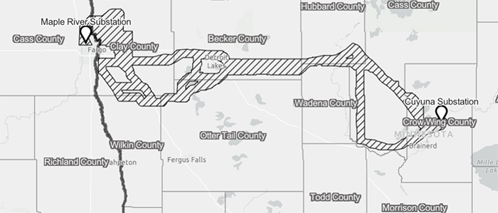
Proposed route for MR-C Transmission Project coming in 2026
News | Published on October 14, 2025 at 4:20pm EDT | Author: frazeevergas
0High-voltage lines expected to run through southern Becker County

Minnesota Power, Otter Tail Power Company, and Great River Energy are currently gathering information from the public to support the development of potential routes for the Maple River- Cuyana (MR-C) Transmission Project. Details of the project are to construct a new, approximately 160-mile-long, single-circuit 345 kilovolt (kV) transmission line on double-circuit capable structures from Minnesota Power’s Cuyuna Substation near Riverton, Minnesota, to Otter Tail Power’s Maple River Substation near Fargo, North Dakota.
By Robert Williams
Editor
Minnesota Power, Otter Tail Power Company, and Great River Energy are currently gathering information from the public to support the development of potential routes for the Maple River- Cuyana (MR-C) Transmission Project.
Details of the project are to construct a new, approximately 160-mile-long, single-circuit 345 kilovolt (kV) transmission line on double-circuit capable structures from Minnesota Power’s Cuyuna Substation near Riverton, Minn., to Otter Tail Power’s Maple River Substation near Fargo, N.D.
Also included are an upgrade of the existing Maple River Substation, located near Fargo and the Cuyuna Substation, located near Riverton, northeast of Brainerd. The projected lines through this area run directly through the southern edge of Becker County following the U.S. Highway 10 corridor from Fargo to Frazee before continuing east to the Hubbard and Wadena county lines.
A more southern route from Fargo to Detroit Lakes includes the northwest corner of Otter Tail County affecting Dunvilla, the Pelican Lake area and running east to just northwest of Vergas (see attached map).
When ready to present a proposed route, the power companies state they will work closely with landowners to answer questions, solicit input and negotiate and gather necessary land rights.
Landowners within the proposed route will receive additional information from the right-of-way team. At this time, the utilities anticipate having a proposed route in the second quarter of 2026.
These high-voltage lines form the backbone of the power grid, delivering large amounts of energy over long distances by minimizing line losses and voltage drops.
Opportunities may exist to locate the project parallel or within an existing high-voltage transmission line corridor. An estimate of up to 30-feet of right-of-way may be shared between existing structures and the new structure depending on engineering, construction and topography. The typical width of the ROW will be at a minimum of 240 feet in areas where ROW is shared with an existing line.
What landowners
can expect
Once a proposed route has been determined, project representatives will contact and meet with individual landowners to discuss the right-of-way (ROW) process, including the need for temporary right-of-entry access, negotiation and acquisition of temporary and permanent land rights, and the restoration and damage process.
It is sometimes necessary to secure additional permanent ROW at angles or areas where site-specific tower designs are used. It could also be necessary to secure temporary areas next to the permanent ROW for stringing and construction access.
Questions can be directed to: connect@mrctransmissionproject.com
For more information, maps, FAQs and more resources visit: www.mrctransmissionproject.com/

